Index of contents
- Flooding Issues
- Planning Compliance Failures
- Minutes of the 2021 AGM
- Report of site meeting with DWH (9 Jul 2021)
- Minutes of the 2022 AGM
1. Thurstan’s Rise Flooding Issues.
by, Peter Hayman
This report was originally prepared in March 2020 to describe the problems which estate residents were experiencing in various places with flooding. Its purpose was to inform the various responsible bodies, so that the appropriate remedial actions could be undertaken. David Wilson Homes are currently engaged in works to deal with many of these issues, and have requested sight of photographic evidence as to the extent of the flooding, to assist them in this. I’ve therefore updated my original report, and enhanced it with photos and videos, which we are now able to share more easily though this website. Thanks to those who contributed to this.
Hopefully, it will also be of interest to other residents, many of whom may be unaware of the full extent, and causes, of the flooding problems.
Background.
The properties most affected by flooding are those along the west side of the estate, from plots 38 to 40 (77 – 81 Blakes Way), plots 41 to 42 (1 – 2 Cadora Way) and, plots 54 to 63 (8 – 26 Cadora Way) along the north side of the estate, bordering the private road leading from Staunton Road to Owen’s Farm.
Before the building of the estate, there was an existing ditch along the west side, between the ‘Open Fields’ denoted on the site plan, and the estate. This ditch was included in the land purchased by David Wilson Homes (DWH) for development. The three plots in the southern corner (38 to 40) back on to the Coleford Natural Burial Ground and it seems that the builders may have deepened this part of the ditch, since the Coleford town clerk believes that it may not have been there, prior to the building of the estate.
The gradient of the ditch breaks roughly between plots 39 and 40, meaning that from that high point about 90% of the water running off the field and part of the Natural Burial Ground, should flow to the north, joining the ditch running down the private farm road. This should then join Sluts Brook, and flow into the central area designated as ‘Public Open Space’ (POS) now known locally as Lake Caudwell!
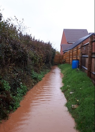
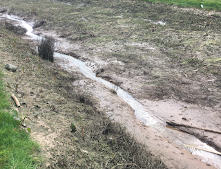
Presumably in order to maximise the number of houses which could be built on the site, DWH decided to install 300mm (12in) diameter, ‘twin-wall’ perforated drainage pipe along three sections of the ditch adjacent to the field. The ditch was then back-filled with soil to cover the drainage pipe and provide these houses with a garden area. Since the soil on the site is mostly clay, which is largely impervious to water, this resulted in major problems for (in particular) plot 41, where the pipe was covered to about a metre depth with heavy clay, making drainage into the underground culvert virtually impossible. This meant that the run-off from the field 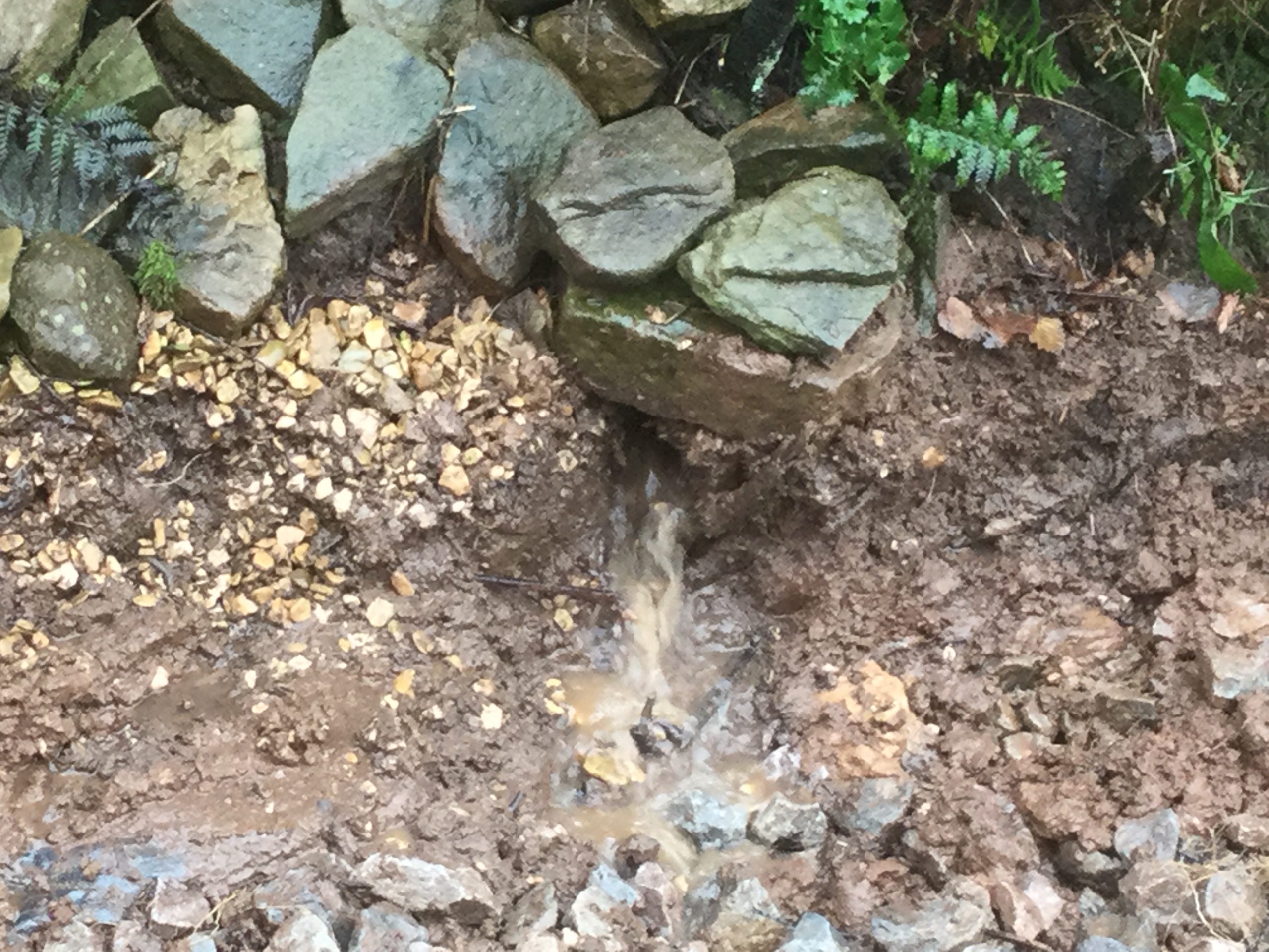 flowed across the garden of plot 41 (View video), and continued down the slopes on either side, also affecting plots 40 and 42, whose garages were subject to flooding. Although DWH have now carried out remedial works at plot 41, digging out the back-filled pipe and installing a gravel filter drain along part of it, these works are unlikely to be fully effective due to the silting up of the underground culvert detailed below, and the sheer volume of run-off at that corner of the field. This was evident during the last heavy rainfall before Christmas. It’s also worth noting that the field to the west has not yet been ploughed, and the stubble from last year’s crop has been left in place. Luckily this reduced the speed at which the water ran off the field, and lessened the impact of December’s heavy rain. A former flood risk engineer from Forest of Dean Council also suggested that a larger size gravel should have been used, to speed up drainage and reduce the amount of silting in the filter drain itself.
The first of the piped sections lies roughly between the south side of the field where it joins plot 40, to the north side of plot 41. The second section runs to the rear of plots 49 to 53, and the final section runs along the south side of plot 54 (8 Cadora Way) and should empty into the ditch running down the private farm road. However, this part of the culvert has been deliberately blocked with concrete, by the owner of Owen’s Farm. Between these underground sections of twin-wall pipe the open ditches remain.
 The first section of twin-wall, to the rear of plot 41, became silted up to about 1/3rd of its diameter after the winter of 2016/17, the first winter of occupation of plots 38 to 41. This resulted in water flowing off the field at the corner adjacent to the Natural Burial Ground, backing up past the break of gradient between plots 39 and 40, and then flowing south into the adjoining ditch belonging to St John’s C of E Primary Academy. This runs down the east side of plot 38 and caused flooding to the rear of the ‘Two Rivers’ housing association property at 30 Oakfields.
The silting of this section of culvert was reported to DWH in late 2016. They took no action other than to send their sub-contractors, EMG, to examine the problem. 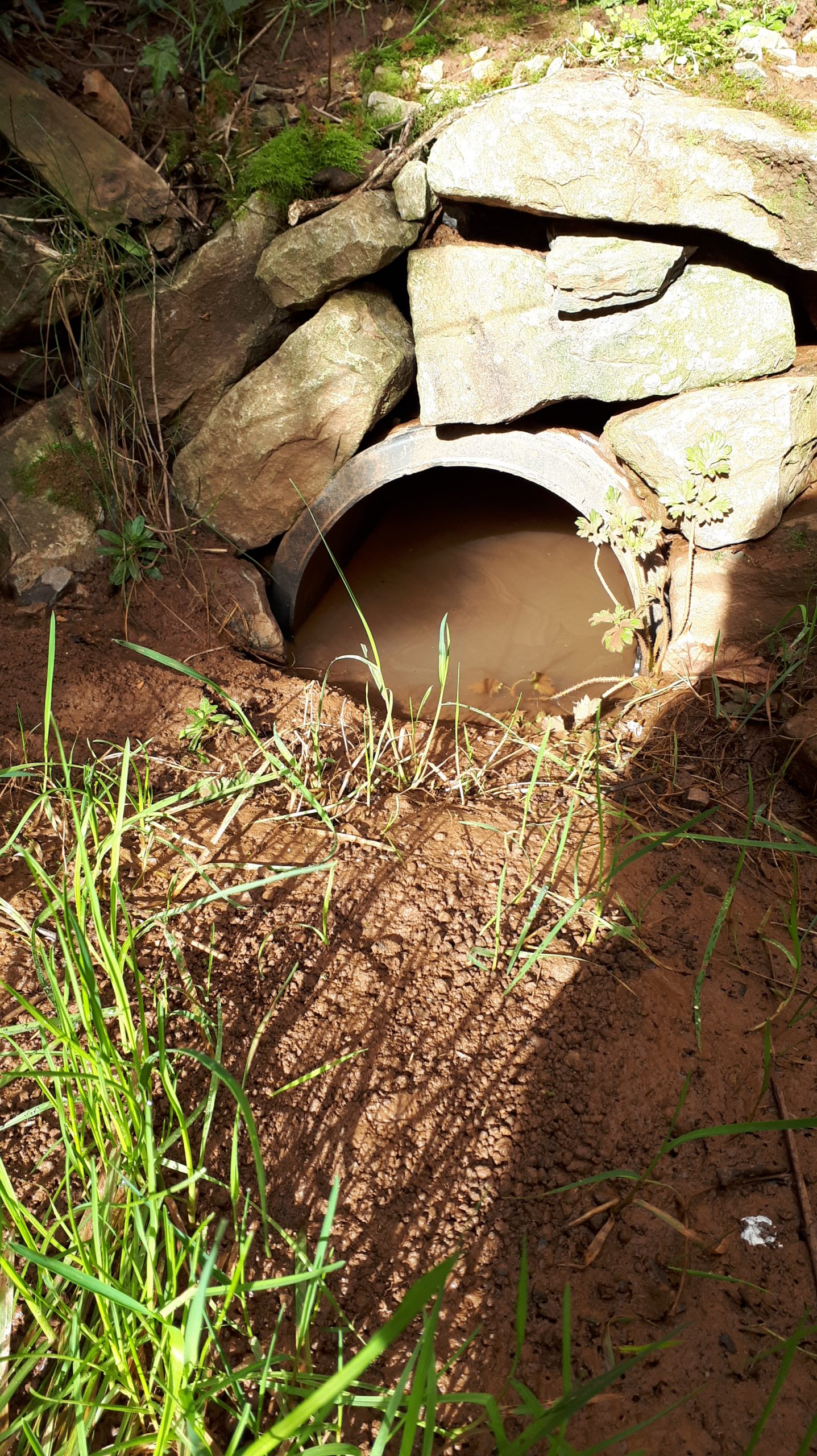 No attempt was made to clear the silt from the blocked culvert. Each subsequent winter has increased the level of silting of this section of twin-wall until it is now completely blocked, despite efforts by the owners of plot 40 to clear the entrance of silt.
During the summer of 2018, with the permission of the school, the owner of plot 38 (the author of this report) excavated the end of the eastern ditch and found that there is a 150mm (6in) pipe leading from the end of the ditch into an inspection chamber in the garden of 30 Oakfields. This however, had been blocked off using a large concrete block, and then back-filled with over a foot of clay soil. Possibly this was done by the builders to prevent polluted water from the site entering the council drains during construction, but according to the tenant at 30 Oakfields, flooding into their garden from the ditch had been a regular occurrence for several years. There is a second 150mm drain pipe leading into the same inspection chamber. This carries water from the traditional graveyard lying between the school and the Recreation Ground.
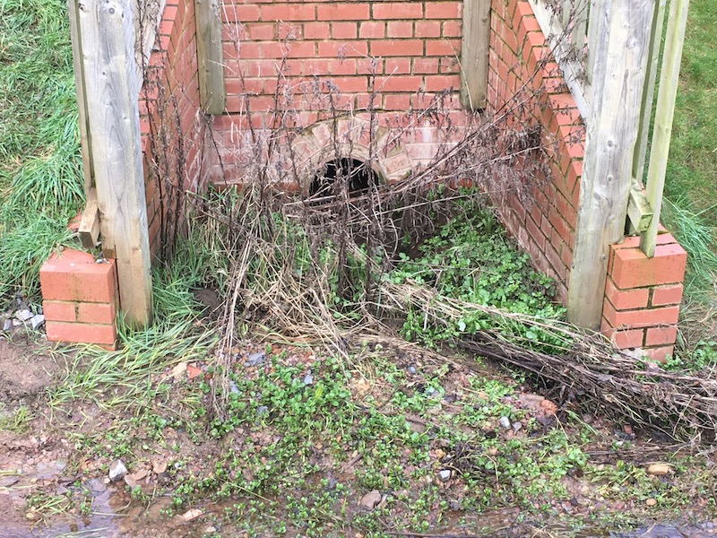
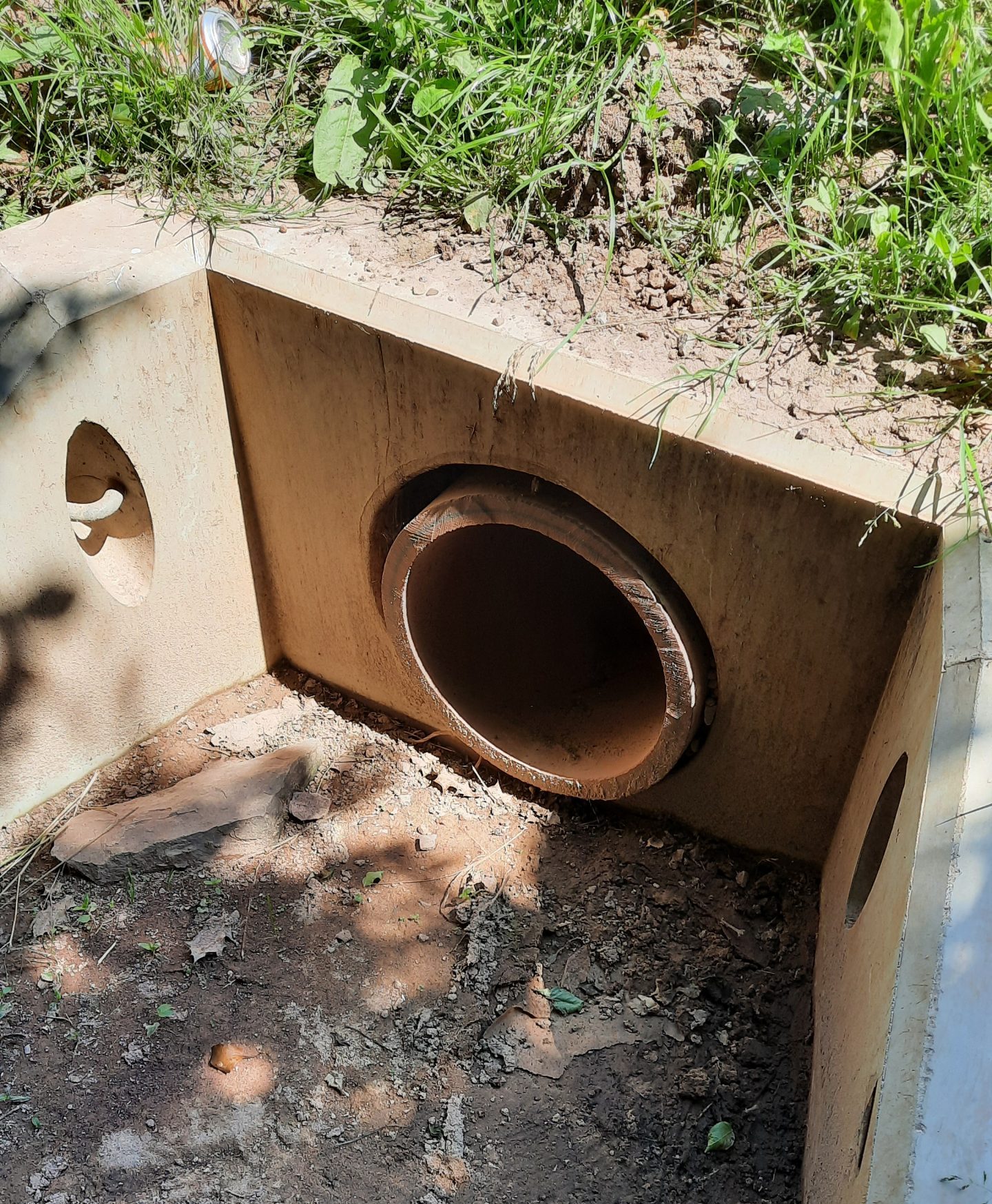
There is however, only a single 150mm outlet pipe from the inspection chamber which carries the water down the eastern side of the estate (on ‘Two Rivers’ land) and empties into the deep brick culvert at the rear of the re-sited children’s playground in the central area of the estate (View video). Concerns have been raised with the Council on several occasions about the safety aspects of this culvert (which lies outside the boundary of the estate), but, to date, no action has been taken.
Recent developments.
Because of the general slope of the field from west to east, probably 70 to 80% of the water draining off it enters the ditch to the rear of plot 40 (View video), and then runs to the south, rather than to the north as intended. Since the twin-wall culvert to the rear of plot 41 is now completely silted up, all the drainage from this corner of the field is forced to run southwards. The volume of this run-off is considerably more than the 150mm outlet pipe from the school’s ditch is able to accommodate. Added to this, Coleford Town Council have channelled water from the Angus Buchanan Recreation Ground down the east side of the Natural Burial Ground and into this ditch.
During heavy rain, the flow into the inspection chamber at 30 Oakfields, from two 150mm pipes, exceeds the capacity of the single 150mm outlet pipe to cope with the volume of water, and this then backs up in the ditch, eventually overtopping the end bank and flooding the property at 30 Oakfields (View video). Because this is at a slightly lower level than plot 38 on this estate, (77 Blakes Way), there is minimal danger of flooding on this plot, other than minor incursions into the front garden, but is potentially very unpleasant for several of the residents of Oakfields, whose gardens back on to those of the houses on Blakes Way.
In early 2020, on behalf of DWH, EMG re-surveyed the ditch behind plots 38 to 40, leading to the blocked culvert to the rear of plot 41, and established that the top of the twin-wall pipe is above the level where the gradient breaks between plots 39 and 40. This means that, even if it were to be cleared, it would be impossible for this culvert to drain all the water entering the ditch. A further problem is that the gradient of the twin-wall pipe itself, is insufficient to maintain a fast enough flow to prevent silt being deposited in it. Once it has been cleared, it will almost certainly require annual maintenance to keep it functioning at all. As the clearance of this culvert will require the use of heavy machinery, it will obviously be beyond the capabilities of the residents of plots 38 to 41 to carry out this maintenance.
In an attempt to reduce flooding to the rear of theirs, and neighbouring properties, the residents at 8 Cadora Way, resorted to digging a trench to lead the run-off from the ditch, down the gully of Cadora Way and into the road drains, which then feed into ‘Lake Caudwell’. During the heavy rains in February 2020, these road drains were barely able to cope with the volume of water, which was reaching the drain at the very foot of Cadora Way despite the intervening road drain holes (View video). The newly laid drain down Cadora Way should alleviate this regular flooding, although there are still some concerns that the volume of water running off the field (View video) may quickly erode the bank and block the new ditches on either side of the headwall. However, when the water which at present flows ‘the wrong way’ to the rear of plots 38 to 40 is re-directed into this new drain, the volume reaching Lake Caudwell will be markedly increased – as will the amount of silt feeding into the lake.
The properties on plots 44 to 49 along Cadora Way, do not apparently have an issue with flooding, as the open ditch along this section is quite deep, but, as the ditch is included in the title deeds as part of their properties, these residents have ‘riparian obligations’ to maintain the ditch to ensure the free flow of water. Since DWH has fenced off their rear gardens however, they have no access to the ditch for these purposes. This matter also needs to be rectified by DWH.
These issues have all been brought to the attention of the Forest of Dean District Council, and their flood risk engineers have visited the site on at least two occasions to examine the affected areas.
Lake Caudwell
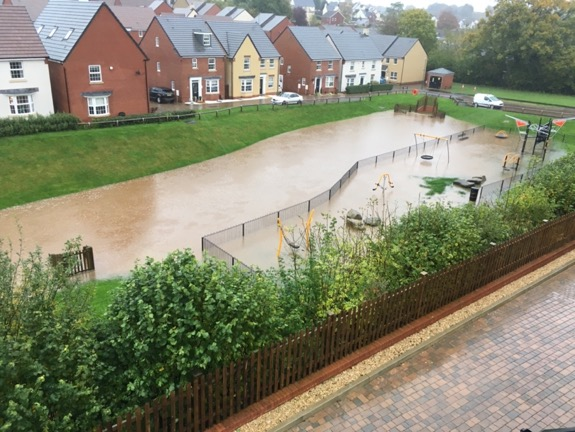
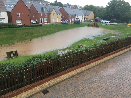
The central area of the estate contains the valley of Sluts Brook, one of three streams which join (now in underground culverts) in the centre of Coleford. This brook rises from a natural spring near Crossways, and flows across the field to the northwest of the estate before entering the central public open space between Inwood Drive and Cadora Way. For much of the year, the brook is little more than a trickle, or completely dries. In winter however, as well as what emerges from the spring, it forms the main drainage channel for all the surrounding fields, and can swell very quickly into a raging torrent carrying a heavy load of silt (View video).
Historically, Sluts Brook has been the cause of regular minor flooding in the neighbouring Oakfields estate. Since the building of Thurstans Rise estate, the increased rapid run-off from hard concrete and tarmac surfaces means that water is channelled into this section of the brook much faster than it was previously. In 2015, during the building of the estate it was the cause of a major flood in Oakfields, which resulted in several vehicles in the car park there being seriously damaged. Following this incident, steps were taken to moderate the flow of the brook, to avoid sudden large volumes of water overwhelming the capacity of the culverts below Oakfields, and further downstream.
It seems that at this stage the installation of a ‘hydro-brake’ was considered, but, presumably on grounds of cost, a simpler ‘orifice plate’ was installed. (This is, as the name suggests, simply a metal plate with a fixed size hole in it, which restricts the water flow to a fixed maximum rate which the culverts downstream are able to accomodate.) Due to this restriction, in times of heavy rain the water will back up in the central area, forming Lake Caudwell, but this should drain completely as soon as the incoming flow rate from the brook falls below the outgoing flow rate allowed by the orifice plate. This should mean that for most of the year, the central public open space is either dry or contains a small free-flowing brook, which sadly has never been the experience of the residents. The probable cause of the blockage of the orifice plate is the quantity of silt washing off the surrounding fields.
Not only is the area smelly, unpleasant and unsightly when not full of water, 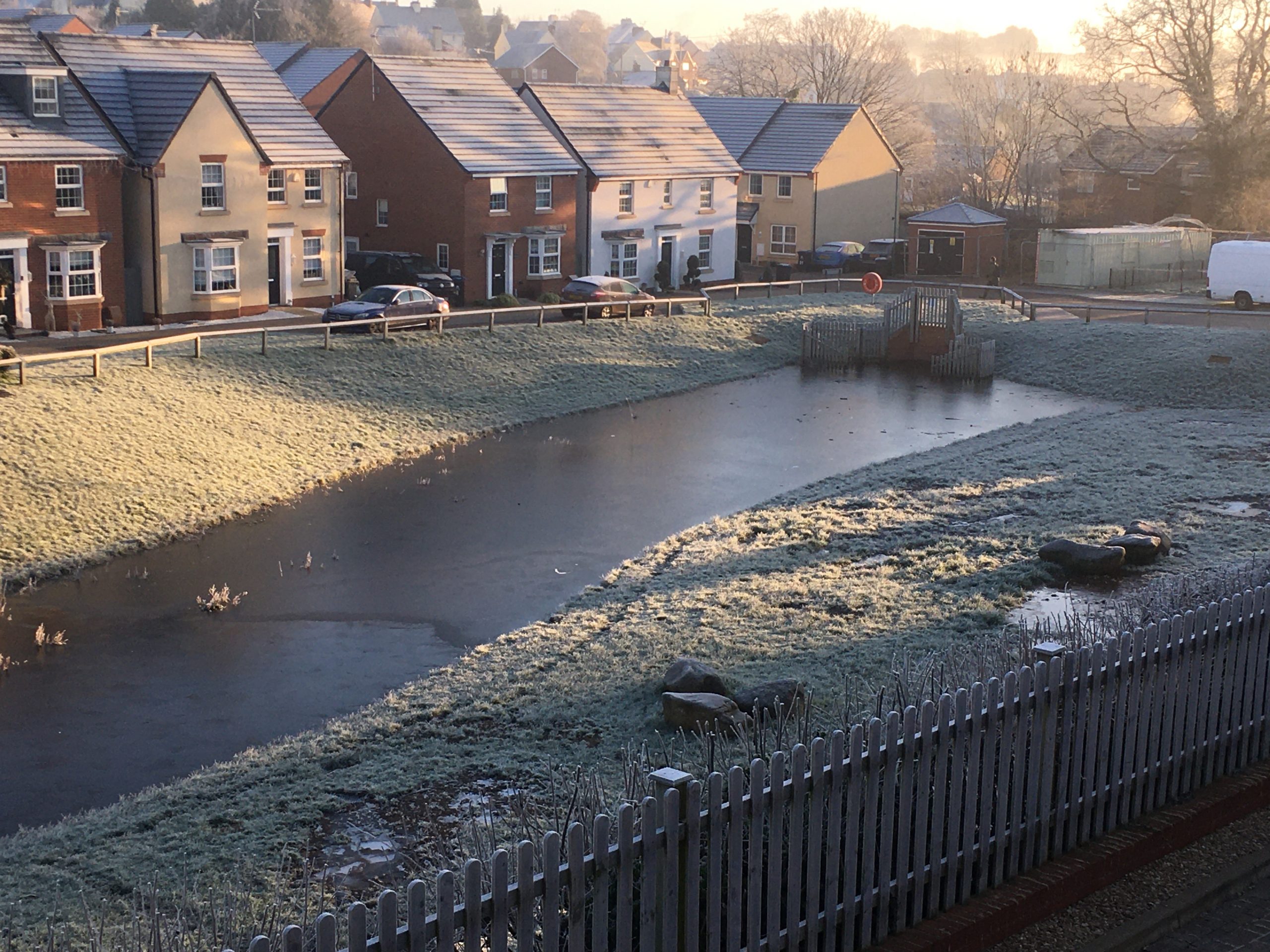 it poses a significant danger – particularly to children – when it is. The incidents over the Christmas and New Year periods when two children fell through the ice on the frozen lake highlighted this, and it is extremely fortunate that to date there have been no fatal accidents. The TRRA chair David Barnham undertook to erect a safety notice warning of thin ice, but in view of the nature of the danger, it is obvious that a permanent solution must be found as a matter of urgency.
2. Report by Simon Oldroyd on
David Wilson Homes – Thurstan’s Rise – Coleford
Failure to comply with planning permission
P1251/12/FUL, P1167/13/FUL, P0061/13/DISCON, P0053/17/FUL, P1112/19/FUL, P0079/20/DISCON, and P0510/20/NONMAT.
(Sent to Forest of Dean Council, Planning Enforcement on 10th February 2021.)
Contents
- Executive Summary
- Introduction
- Drainage and Flooding Problems
- Landscaping
- Building Control Issues
- Conclusion
1.0 Executive Summary
David Wilson Homes applied for planning permission in 2012 to erect 156 dwellings, including garages, landscaping and public open space on land adjacent to Owens Farm, GL16 8QR.
Permission was granted on 12th April 2013, with building work commencing in 2014 and continuing until 2018, when all building and landscaping works were deemed to have been completed.
However, as this report will evidence, a number of serious drainage problems remain unresolved, the majority of the landscaping is still uncompleted and many drain covers around the site are not in accordance with building regulations.
Specifically, we would like to draw your attention to five main breaches of planning:
- The failure to provide adequate drainage via the main watercourse (Sluts Brook), causing a flooded lake to form across the public open space for many months of the year, every year.
- The failure to re-grade the open watercourse on the south west boundary of the estate, so that it falls in a northerly direction towards the new drainage inlet headwall at the top of Cadora Way.
- The failure to re-grade the pipe work inside the covered filter drain on the south west boundary of the estate so that it also falls in a northerly direction towards the new inlet headwall.
- The failure to undertake the majority of the landscaping, as detailed within the landscaping proposals.
- The failure to install the correct drain covers, contrary to building control regulations.
2.0 Introduction
Over the past 4 years many individual residents within Thurstan’s Rise have attempted, without success, to liaise with DWH (David Wilson Homes) to ensure that Thurstan’s Rise was completed as documented within the various plans submitted in planning applications P1251/12/FUL, P1167/13/FUL, P0061/13/DISCON, P0053/17/FUL, P1112/19/FUL, P0079/20/DISCON, and P0510/20/NONMAT.
Realising, about a year ago, that individual complaints were either being evaded, or ignored altogether, it was decided to form the TRRA (Thurstan’s Rise Residents’ Association) – https://thurstansrise.org.uk – as a collective means of working with DWH to ensure they not only resolved the many problems that had arisen from poor detailed planning, but also to ensure that they complied with the overall designs on which planning permission was granted.
Having attempted to work with DWH to resolve the many issues over the past year, the TRRA is now of the opinion that the various planning breaches will not be resolved through further discussions with DWH, due to their continued inaction and their broken promises.
The various outstanding issues affect the public amenities within the estate, and the poor drainage provision is contrary to public interest as well as being harmful to the neighbourhood.
We believe that the main issues fall into three categories:
Each of these is detailed within this report.
3.0 Drainage and Flooding problems
3.1 Background
The properties that have been most affected by flooding are those along the west side of the estate, from plots 38-40 (77–81 Blakes Way), plots 41-42 (1–2 Cadora Way) and, plots 54-63 (8–26 Cadora Way) along the north side of the estate, bordering the private road leading from Staunton Road to Owen’s Farm.
Before the building of the estate, there was an existing ditch along the west side, between the ‘Open Fields’ denoted on the site plan, and the estate. This ditch was included in the land purchased by David Wilson Homes (DWH) for development. The three plots in the southern corner (38-40) back on to the Coleford Natural Burial Ground and it seems that the builders may have deepened this part of the ditch, since the Coleford town clerk believes that it may not have been there, prior to the building of the estate.
The gradient of the ditch breaks roughly between plots 39 and 40, meaning that from that high point about 90% of the water running off the field and part of the Natural Burial Ground, should flow to the north, joining the ditch running down the private farm road. This should then join Sluts Brook, and flow into the central area designated as ‘Public Open Space’ (POS) now known locally as “Lake Caudwell”.
Presumably, in order to maximise the number of houses which could be built on the site, DWH decided to install 300mm (12in) diameter, ‘twin-wall’ perforated drainage pipe along three sections of the ditch adjacent to the field. The ditch was then back-filled with soil to cover the drainage pipe and provide these houses with a garden area. Since the soil on the site is mostly clay, which is largely impervious to water, this resulted in major problems for (in particular) plot 41, where the pipe was covered to about a metre depth with heavy clay, making drainage into the underground culvert virtually impossible.
This meant that the run-off from the field flowed across the garden of plot 41
(View video), and continued down the slopes on either side, also affecting plots 40 and 42, whose garages were subject to flooding.
 Although DWH have now carried out remedial works at plot 41, digging out the back-filled pipe and installing a gravel filter drain along part of it, these works are unlikely to be fully effective due to the silting up of the underground culvert detailed below, and the sheer volume of run-off at that corner of the field.
This was evident during the last heavy rainfall before Christmas (2020). It’s also worth noting that the field to the west has not yet been ploughed, and the stubble from last year’s crop has been left in place. Luckily this reduced the speed at which the water ran off the field, and lessened the impact of December’s heavy rain.
A former flood risk engineer from Forest of Dean Council also suggested that a larger size gravel should have been used, to speed up drainage and reduce the amount of silting in the filter drain itself.
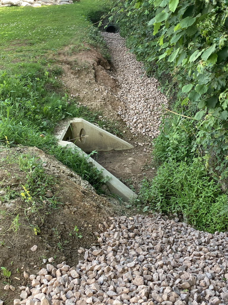
The first of the piped sections lies roughly between the south side of the field where it joins plot 40, to the north side of plot 41. The second section runs to the rear of plots 49 to 53, and the final section runs along the south side of plot 54 (8 Cadora Way) and should empty into the ditch running down the private farm road. However, this part of the culvert has been deliberately blocked with concrete, by the owner of Owen’s Farm. Between these underground sections of twin-wall pipe the open ditches remain.
The first section of twin-wall, to the rear of plot 41, became silted up to about 1/3rd of its diameter after the winter of 2016/17, the first winter of occupation of plots 38 to 41.
This resulted in water flowing off the field at the corner adjacent to the Natural Burial Ground, backing up past the break of gradient between plots 39 and 40, and then flowing south into the adjoining ditch belonging to St John’s C of E Primary Academy. This runs down the east side of plot 38 and caused flooding to the rear of the ‘Two Rivers’ housing association property at 30 Oakfields.
The silting of this section of culvert was reported to DWH in late 2016. They took no action other than to send their sub-contractors, EMG, to examine the problem.  No attempt was made to clear the silt from the blocked culvert. Each subsequent winter has increased the level of silting of this section of twin-wall until it is now completely blocked, despite efforts by the owners of plot 40 to clear the entrance of silt.
During the summer of 2018, with the permission of the school, the owner of plot 38 excavated the end of the eastern ditch and found that there is a 150mm (6in) pipe leading from the end of the ditch into an inspection chamber in the garden of 30 Oakfields. This however, had been blocked off using a large concrete block, and then back-filled with over a foot of clay soil. Possibly this was done by the builders to prevent polluted water from the site entering the council drains during construction, but according to the tenant at 30 Oakfields, flooding into their garden from the ditch had been a regular occurrence for several years. There is also a second 150mm drain pipe, leading into the same inspection chamber, which carries water from the traditional graveyard lying between the school and the Recreation Ground.
There is however, only a single 150mm outlet pipe from the inspection chamber which carries the water down the eastern side of the estate (on ‘Two Rivers’ land) and empties into the deep brick culvert at the rear of the re-sited children’s playground in the central area of the estate (View video).
Concerns have been raised with the Council on several occasions about the safety aspects of this culvert and the dangerous drop into the headwall area, but, to date, no action has been taken.
3.2 Recent Developments
Because of the general slope of the field from west to east, probably 70% to 80% of the water draining off it enters the ditch to the rear of plot 40 (View video), and then runs to the south, rather than to the north as intended. Since the twin-wall culvert to the rear of plot 41 is now completely silted up, all the drainage from this corner of the field is forced to run southwards. The volume of this run-off is considerably more than the 150mm outlet pipe from the school’s ditch is able to accommodate. Added to this, Coleford Town Council have channelled water from the Angus Buchanan Recreation Ground down the east side of the Natural Burial Ground and into this ditch.
During heavy rain, the flow into the inspection chamber at 30 Oakfields, from two 150mm pipes, exceeds the capacity of the single 150mm outlet pipe to cope with the volume of water, and this then backs up in the ditch, eventually overtopping the end bank and flooding the property at 30 Oakfields (View video). Because this is at a slightly lower level than plot 38 on this estate, (77 Blakes Way), there is minimal danger of flooding on this plot, other than minor incursions into the front garden, but is potentially very unpleasant for several of the residents of Oakfields, whose gardens back on to those of the houses on Blakes Way.
In early 2020, on behalf of DWH, EMG re-surveyed the ditch behind plots 38 to 40, leading to the blocked culvert to the rear of plot 41, and established that the top of the twin-wall pipe is above the level where the gradient breaks between plots 39 and 40. This means that, even if it were to be cleared, it would be impossible for this culvert to drain all the water entering the ditch.
A further problem is that the gradient of the twin-wall pipe, itself, is insufficient to maintain a fast enough flow to prevent silt being deposited in it. Once it has been cleared, it will almost certainly require annual maintenance to keep it functioning at all. As the clearance of this culvert will require the use of heavy machinery, it will obviously be beyond the capabilities of the residents of plots 38 to 41 to carry out this maintenance.
In an attempt to reduce flooding to the rear of theirs, and neighbouring properties, the residents at 8 Cadora Way, resorted to digging a trench to lead the run-off from the ditch, down the gully of Cadora Way and into the road drains, which then feed into ‘Lake Caudwell’.
During the heavy rains in February 2020, these road drains were barely able to cope with the volume of water, which was reaching the drain at the very foot of Cadora Way despite the intervening road drain holes (View video). The newly laid drain down Cadora Way should alleviate this regular flooding, although there are still some concerns that the volume of water running off the field (View video) may quickly erode the bank and block the new ditches on either side of the headwall.
However, when the water which at present flows ‘the wrong way’ to the rear of plots 38 to 40 is re-directed into this new drain, the volume reaching Lake Caudwell will be markedly increased – as will the amount of silt feeding into the lake.
The properties on plots 44 to 49 along Cadora Way, do not apparently have an issue with flooding, as the open ditch along this section is quite deep, but, as the ditch is included in the title deeds as part of their properties, these residents have ‘riparian obligations’ to maintain the ditch to ensure the free flow of water. Since DWH has fenced off their rear gardens however, they have no access to the ditch for these purposes. This matter also needs to be rectified by DWH.
These issues have all been brought to the attention of the Forest of Dean District Council, and their flood risk engineers have visited the site on at least two occasions to examine the affected areas.
Although DWH attempted to address some of the above problems via their planning application P0510/20/NONMAT, many of the issues still exist.
3.3 ‘Lake Caudwell’
The central area of the estate contains the valley of Sluts Brook, one of three streams which join (now in underground culverts) in the centre of Coleford. This brook rises from a natural spring near Crossways, and flows across the field to the northwest of the estate before entering the central public open space between Inwood Drive and Cadora Way. For parts of the year, the brook is little more than a trickle, or completely dries.
In winter however, as well as what emerges from the spring, it forms the main drainage channel for all the surrounding fields, and can swell very quickly into a raging torrent carrying a heavy load of silt (View video).
Historically, Sluts Brook has been the cause of regular minor flooding in the neighbouring Oakfields estate. Since the building of Thurstan’s Rise estate, the increased rapid run-off from hard concrete and tarmac surfaces means that water is channelled into this section of the brook much faster than it was previously. In 2015, during the building of the estate it was the cause of a major flood in Oakfields, which resulted in several vehicles in the car park there being seriously damaged. Following this incident, steps were taken to moderate the flow of the brook, to avoid sudden large volumes of water overwhelming the capacity of the culverts below Oakfields, and further downstream.
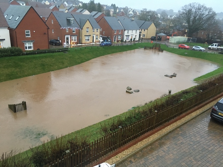
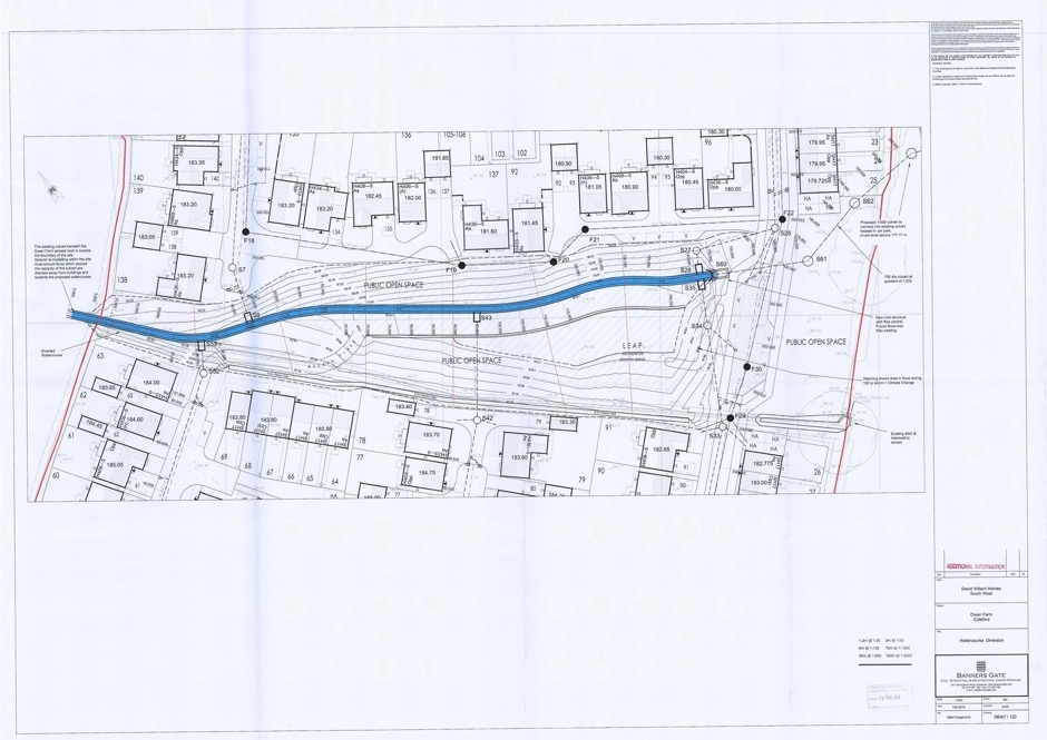
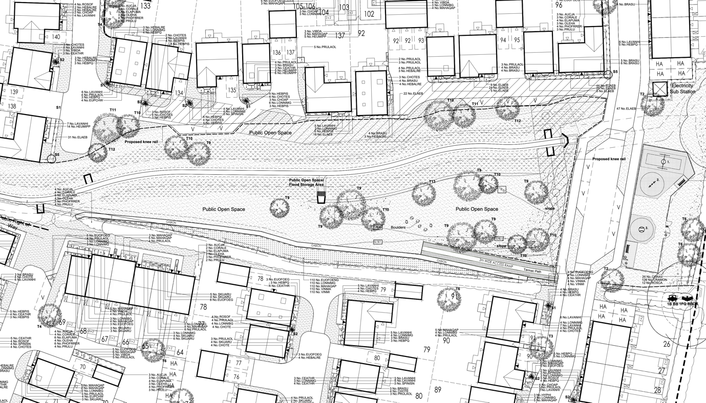
It seems that at this stage the installation of a ‘hydro-brake’ was considered, but, presumably on grounds of cost, a simpler ‘orifice plate’ was installed. (This is, as the name suggests, simply a metal plate with a fixed size hole in it, which restricts the water flow to a fixed maximum rate which the culverts downstream are able to accommodate.) Due to this restriction, in times of heavy rain the water will back up in the central area, forming ‘Lake Caudwell’, but this should drain completely as soon as the incoming flow rate from the brook falls below the outgoing flow rate allowed by the orifice plate. This should mean that for most of the year, the central public open space is either dry or contains a small free-flowing brook. Below is the plan, submitted by DWH, to show the watercourse diversion:
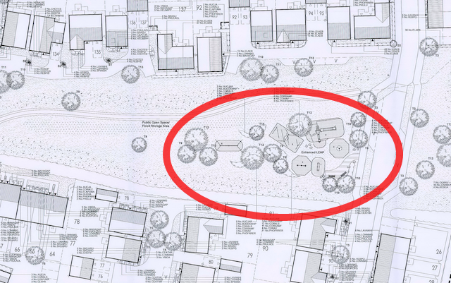
A provision was shown in the DWH proposed drainage layouts (as submitted for planning permission) for the public open space to ‘double’ as a flood storage area for a “100-year flood” (shown below with a red outline):
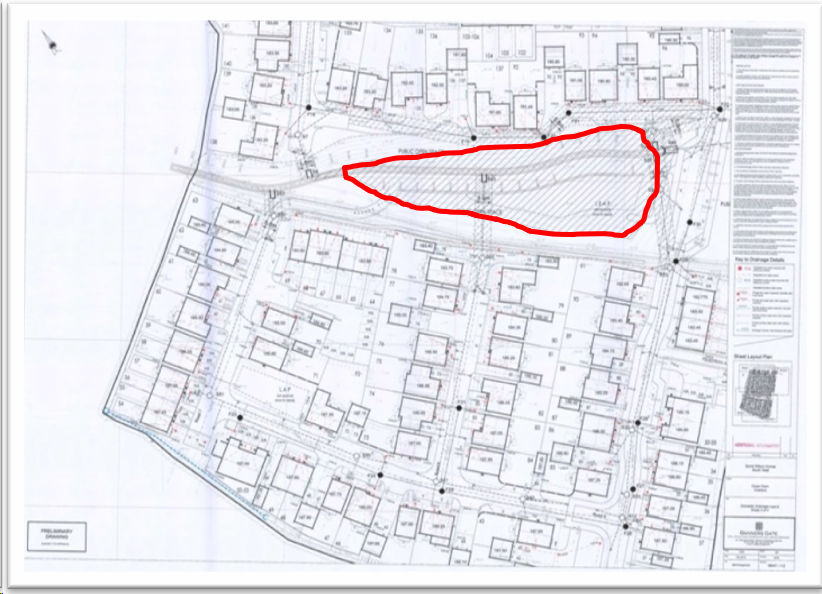
This means that DWH were predicting that there was only a 1 in 100 chance (1% probability) of a ‘flood event’ being equalled or exceeded in any given year.
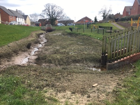
Sadly, neither the free-flowing brook nor the landscaped POS (public open space) has ever been the experience of the residents, due to the main drainage from the estate (Sluts Brook) being continually silted up, resulting in the POS being either under water, or a waste land:
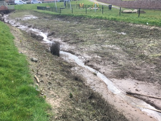
Prior to the LEAP (Local Equipped Area for Play) being re-sited (planning application P1112/19/FUL), the play park spent much of its life under water:
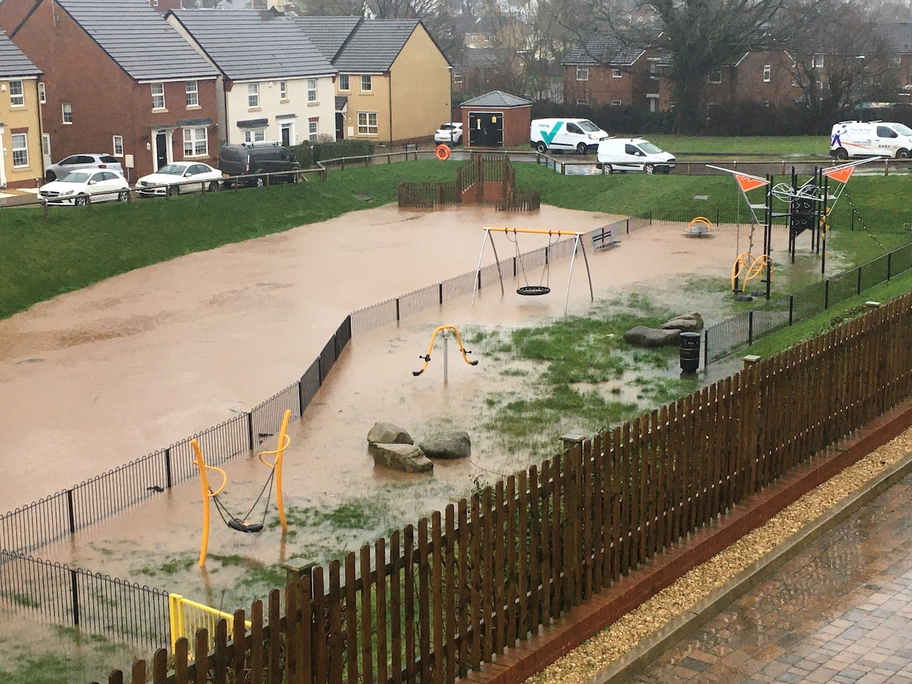
The probable cause of this is a blockage of the orifice plate by the quantity of silt washing off the surrounding fields and into Sluts Brook. Not only is the area now smelly, unpleasant and unsightly when not full of water, it poses a significant danger – particularly to children – when it is.
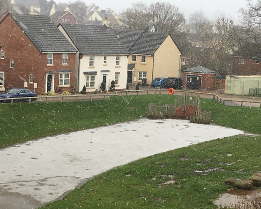
The incidents over the Christmas and New Year periods when two children fell through the ice on the frozen lake highlighted this, and it is extremely fortunate that to date there have been no fatal accidents.
The TRRA undertook to erect a safety notice warning of thin ice, but in view of the nature of the danger, it is obvious that a permanent solution must be found as a matter of urgency.
DWH have continually maintained that the estate main drainage system (Sluts Brook) is working perfectly and that “Lake Caudwell” was always planned as a ‘balancing pond’, even though there is no reference whatsoever to this on any of the drainage or landscape plans submitted to Planning.
It is also worth noting that if a balancing pond was intended, as they claim, then why also plan to build a children’s play park (LEAP) in the middle of it…..?
4.0 Landscaping
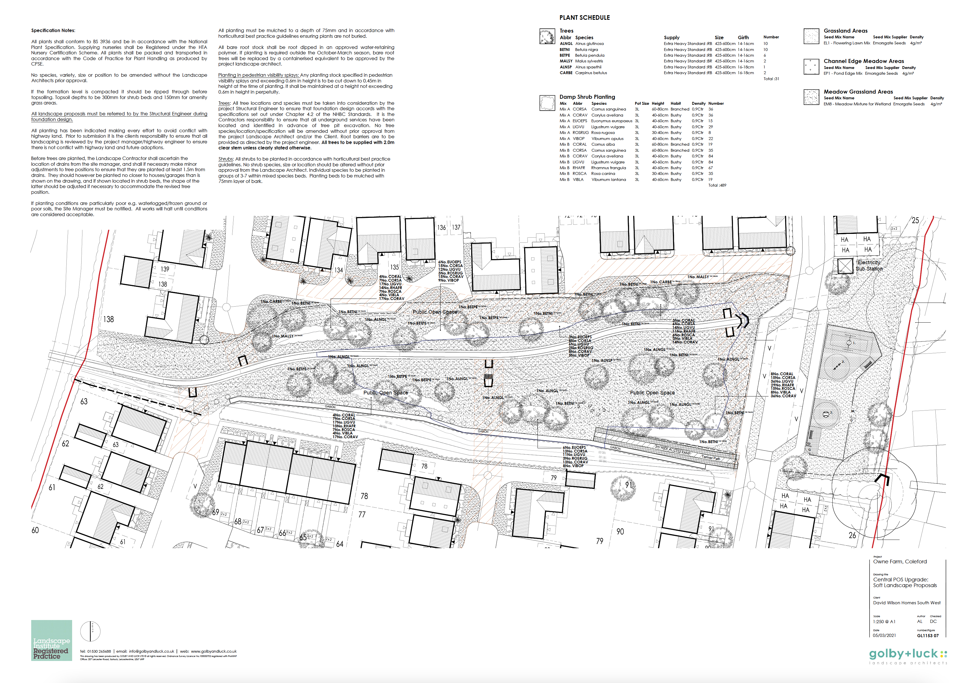
Despite numerous requests to DWH over the past four years (and many broken promises from their directors), DWH have continually failed to complete much of the landscaping across the site, as per their submitted landscaping proposals (P1251/12/FUL and P1112/19/FUL) and as specified in their most recent drawings:
- GL1153 04A, dated 16/07/2019 (Golby + Luck)
- GL1153 05B, dated 19/06/2019 (Golby + Luck)
- GL1153 06A, dated 16/06/2019 (Golby + Luck)
An example of which is shown below:
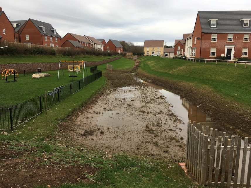
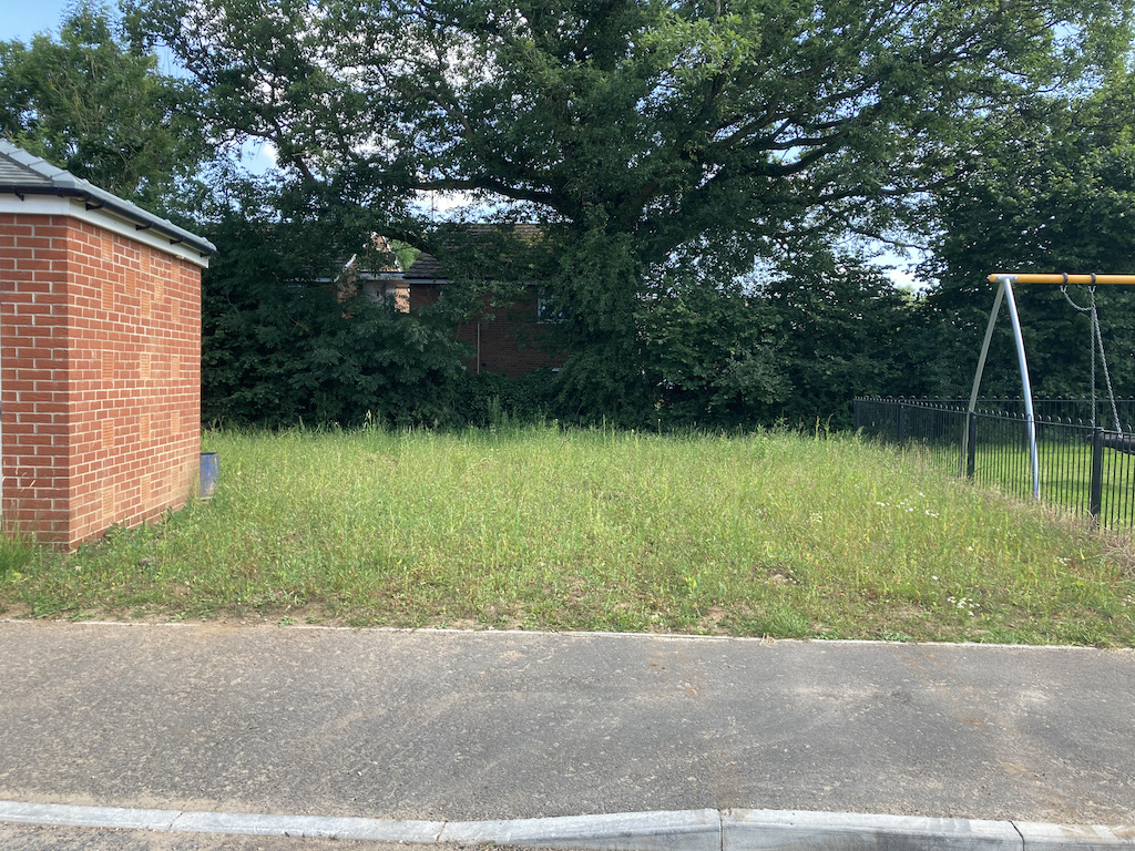
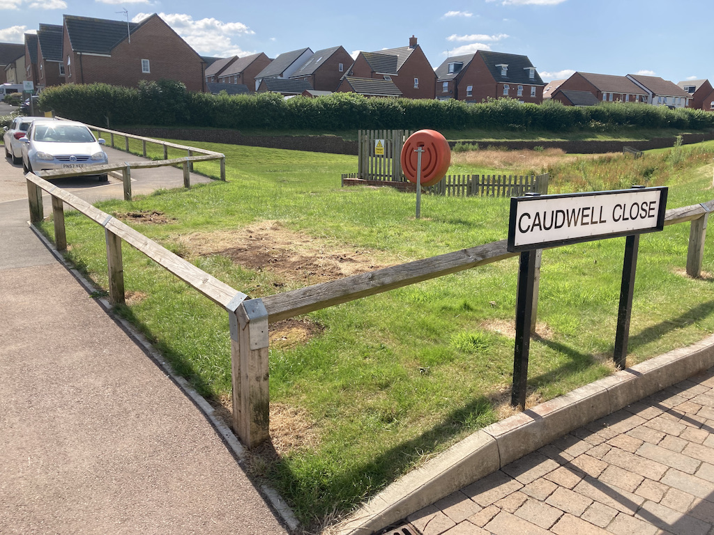
The Public Open Space (currently Lake Caudwell) remains a waste land when it isn’t flooded (during 6 months of the year), despite this supposedly being one of the main features of the Thurstan’s Rise planning concept.
The detailed landscape proposals within P1112/19/FUL (approved on 13th February 2020) specify – within the public open space – a meadow mixture of wild flowers (11 varieties), meadow grasses (4 varieties), stream edge wild flowers (18 varieties), stream edge grasses (7 varieties), as well as 24 trees and 550 shrubs and bushes on top of the gabion wall to prevent soil erosion.
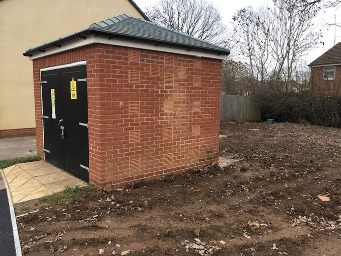
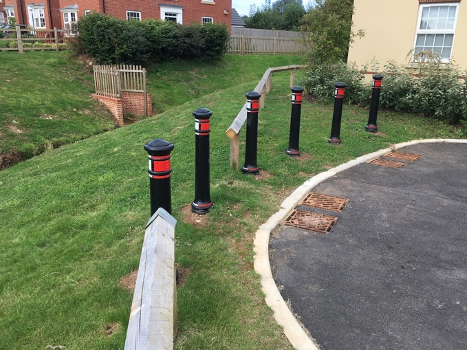
Around the electricity substation (and adjacent parking area) 47 hedging plants and 26 shrubs are detailed on the plan; however, none are in evidence. And the knee-rail section at the bottom of Inwood Drive – removed when bollards were installed – awaits reinstallation:
Alongside this, the rubble from when the headwall drainage outlets were originally built (4 years ago) has never been cleared of bricks and builders rubbish and this remains a problem, inhibiting rain water drainage.
Of the very few trees that have been planted, many have now died.
5.0 Building Control Issues
5.1 Drain Covers
Many of the ‘Polypipe’ plastic drain covers that have been installed on property driveways are only rated as ‘pedestrian’ (FACTA A – 5kN) which is in breach of building regulations and, unsurprisingly, they have cracked when driven over:
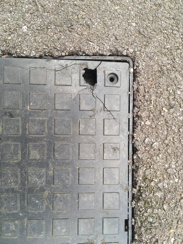
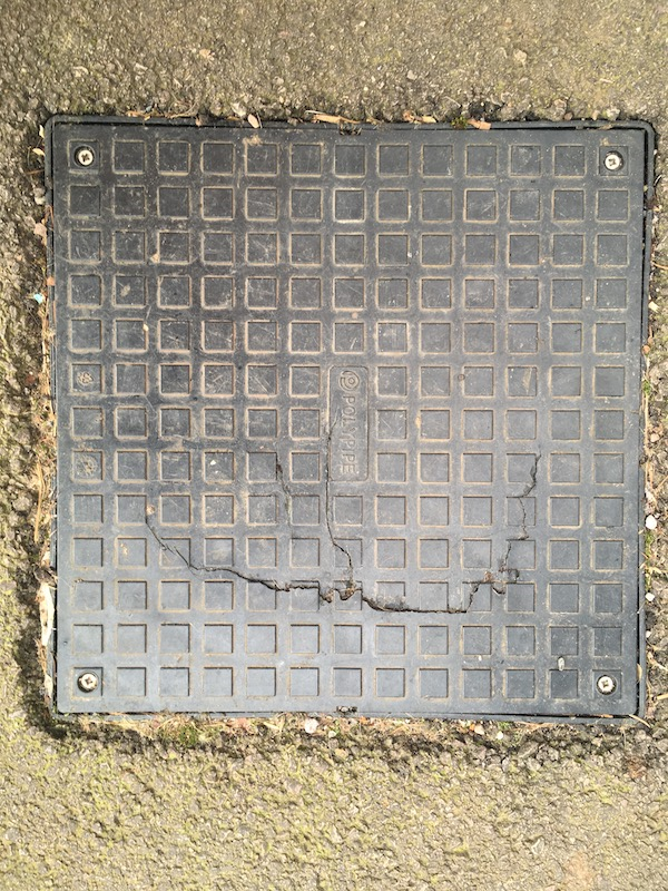
DWH assured us, last summer (2020), that an audit would be undertaken across site to ascertain which drain covers had been incorrectly installed and that these would be replaced with correctly specified ones. However, this hasn’t happened and many of the existing drain covers remain contrary to building regulations, whilst also representing a health and safety issue.
Despite offering to help DWH with this audit, by providing a ‘reporting’ portal on the TRRA website, no remedial action would appear to be planned.
6.0 Conclusion
The TRRA believes that all of the above issues should have been either dealt with, or completed, prior to DWH leaving site.
However, it’s now two and a half years since DWH departed site and, despite continued efforts to get them to rectify the many outstanding problems, they continue to both prevaricate and dissemble.
The only option that we now appear to have left to us is to involve the Planning Enforcement Team, to ensure that DWH solve the drainage issues, complete the landscaping works and comply with building regulations, prior to the adoption of the estate by the council.
The outcome that we are looking for is, quite simply, that DWH complete the site as specified within the detailed planning documents which they submitted as part of their planning applications.
They need to:
- Recognise and rectify the inadequate drainage solutions that currently exist on the site, both with regard to the incorrectly graded culverts and filter drains on the western boundary of the development, and also the major problem of flooding within the public open space.
- Complete all landscaping works, as per the planting schedule provided within their submitted documentation.
- Replace all the incorrectly specified drain covers to meet building regulations.
We hope that the Planning Enforcement Team can fully engage with these breaches of planning and we welcome both your comments and your proposed action plan.
Simon Oldroyd
TRRA Committee Member
3. Minutes of the TRRA AGM, 7th April 2021
Attendees: Helen Barnham, Donna Albon, Simon Oldroyd, Dave Barnham, Leslie and Paul Ramm, Barrie Powles, Jean Hayman, Helen and Ian Crawford, Kirsty Aston, Joe Randall, Peter Hayman, Slawek Rakowski, Philip King, Angela Lewis. [Two additional attendees were present with the following screen names: Galaxy Tab A, and iPAD (2).]
Apologies: Paul Cooper, Alie Ingham.
1. Approval of Constitution
There were no adverse comments received, and no votes against the current draft constitution. Therefore, it was deemed that the constitution was accurate and represents what we will work from for the next year, and was unanimously adopted.
2. Chair’s Statement by David Barnham
Looking Back over the last 12 months
- Since our inaugural meeting on the 6th February 2020 where we agreed to establish TRRA, I believe that we have come a very long way along the road of change, which will lead to a completed estate that fosters a friendly and family atmosphere, putting in the foundations of a community estate that thrives on togetherness.
- In the last 12 months we have gained support from the Town Council, prevented residents from being locked into the estate, made positive impacts to the remedial works that have been conducted on the estate and many, many other things.
- None of this would have been at all possible without the full support of the TRRA committee.
- I would therefore like to thank the following people, starting with our exceptional committee without whom, TRRA would not have achieved anything this year:
- Donna Albon – Donna is our Secretary, and over the last year has had the unenviable task of ensuring that TRRA meeting minutes have all been recorded and has been a vital and valued committee member supporting all TRRA activity including the creation of vital external meeting records. Donna has been pivotal with her ideas and enthusiasm, and has always acted with level-headedness helping to resolve issues with positive outcomes.
- Paul Cooper – who has for the past 12 months been our Treasurer, establishing our finance rules, setting TRRA up with a bank account, collecting in the finances and where required, paying the bills. Paul has informed us though, that whilst he will continue to be a member of TRRA, he will sadly be stepping down as Treasurer to pursue other personal opportunities. Paul, thank you so much for everything you have done, and we would like to take the opportunity to give you a small leaving gift, from the committee members, on behalf of the association. (Please check your doorstep and you will find a token of our appreciation!)
- Peter Hayman – Our Webmaster, the brains behind our professional website. Peter has done us proud and has created a website that most professional organisations would be proud to have. Peter additionally updates the website on a regular basis and writes the most fantastic pieces of news for us to consume. In addition to this Peter has also collated and written the most comprehensive report on the flooding issues this estate has suffered from. It is this report alongside the TRRA action that enabled the remedial work to be completed at the top of the estate and hopefully change the outlook for those who have suffered the worst conditions whenever it rained. Regardless, I assure you Peter will have his eye on the estate to ensure that flood protection and drainage remains one of our driving priorities.
- Simon Oldroyd – Simon likes to be known as the man with no title, but can I say he has assumed the role of watchdog – Simon has tirelessly tackled numerous issues on our behalf, acting as the lead communicator with DWH, Stonewater and other organisations. It is with Simon’s drive that we have managed to secure corporate membership for all Stonewater residents. Simon, you have done a tremendous job holding DWH to the letter of their promises, I genuinely believe you do not understand the word no! Your tenacity and constant barrage of emails/calls has certainly been noted by anyone who has been on the unfortunate end of your disapproval.
- Helen Barnham – Helen has acted as a firm supporter of TRRA, and agreed to be co-opted as a non-voting member of the committee. Helen is also one of our town councillors and acts as our bridge into the Coleford Town Council, where she has agreed to facilitate meetings with DWH as well as facilitating this meeting. Helen, we would also like you to pass a huge thank you to Nick Penny as Mayor, and all of the Town Councillors who have supported us getting this far and for recognising us as a professional organisation, here for the good of the residents of Thurstan’s Rise and supporting the Town of Coleford.
- Each of you will also find a little something from me on your doorstep to say thank you.
- Members – Finally it is without doubt that a huge thank you is due to you all for putting your trust and faith in us, allowing TRRA to be the organisation that represents your best interests. We recognise that membership comes at a small fee, but we hope that you recognise the value which we have given you for your investment.
- It has been a privilege to have been voted in last year as the Chair of this association, a privilege I have never taken lightly and always strive to keep the best interests of our members in the forefront of my mind when making any decisions.
Looking Forward over the next 12 months
- Before we can look forward, we must understand where we are today and without trying to steal Simon’s thunder, I would just like to say we are on the racetrack, but the finish line with DWH is still some way in the distance. Simon will update us all on where the work with DWH is, within his section of this AGM.
- We are looking at trying to ascertain, with the help of CTC, if there is any ‘Section 106’ money that has been allocated to this estate and not yet spent. This is money that DWH would have put into a pot to enable projects that benefit the residents of the estate to be accomplished. We have formally requested this money and are now awaiting a response.
- So, what does the next 12 months hold?
- We would like to continue to put pressure on DWH to complete the estate to plan – this is being accomplished with the use of an enforcement notice.
- We would like to hold a community celebration, once CV-19 restrictions are lifted and allow us to be together as a community once more. We will be looking to you all for ideas about what you want.
- We will continue to look at the options of us being a part of the board which maintains the estate, determining if we can get better value for money when it comes to us paying for the upkeep and maintenance.
- We would like to continue to grow our committee membership as well as improve our membership base, to a point where we represent the best interests of nearly all residents of the estate.
- We would like you to provide us with feedback if we aren’t getting things right and let us know how we can improve to represent you better. We would also like your ideas on what we need or can do together as a community.
3. Finance update
An external audit was completed by Ian Crawford, who certified that the accounts were in order.Treasurer’s Report – 7th April 2021
Finances
Cash in hand: £41.22
Bank balance: £195.00
There are no liabilities outstanding.
The HSBC bank account was eventually opened on 19th October 2020, delayed due to covid impact on the bank. This account is of the type specifically for charities and associations and operates fully online.
Membership
Number of paid members: 38
A further 20 residents have registered an interest but have yet to subscribe.
Total membership fees collected: £195
Stonewater contribution: £100
Website advertising
All companies with adverts on the TRRA website have paid. This equates to £215. Adverts were for a 12-month period and are due for renewal on 30th September 2021.
Slawek Rakowski questioned the structure of the membership year, and asked why the membership does not have a fixed start date e.g., 1 April.
Peter Hayman explained that the original constitution had been amended to make the membership year run for twelve months from the date of joining, and not from a fixed date. It was discussed that this will potentially need revising to simplify things going forward.
4. Coleford Town Council update, from Helen Barnham
CTC have formally complained to Highways about the lack of warning ahead of the road works last year. Highways did not consult CTC ahead of the works and following a complaint from CTC there is now a working team who have direct access to Highways. Highways regularly send schedules to the council for upcoming road works to avoid similar issues.
Members of the public are welcome to attend any committee meetings as well as the planning meetings. Objections still ongoing with regards to Thurstan’s Rise development and the planning office.
The Covid lockdowns have hit Coleford badly, and so the CTC plan to revive the town. They are therefore excited to announce that commencing 17th April, Coleford will host a full Town Market on the 3rd Saturday of every month, hosting a variety of stalls from local suppliers. Please do support this event.
Youth activities have been planned for the Easter holidays in a bid to tackle youths hanging around the town centre, and for those age groups for whom there is nothing to do.
5. Estate works update, Simon Oldroyd
Current status
I’m sure that you will all have been avidly following the various updates on our Website so, for the purposes of this short report, I’m taking it that you’re all aware of what has been achieved so far and am simply going to focus on the current situation.
The report is in two short sections. The first is an update on where we are with DWH’s completion of site, and the second is on the recent report that the TRRA submitted to Planning Enforcement.
DWH
- EMG were instructed to collect the pipes from the bottom of Cadora Way, and this has now happened.
- The Heras fencing (which is sitting at the junction of Caudwell Close and Blakes Way) is going to remain there for a bit, as additional work needs to be undertaken, as instructed by the Highways Officer.
- These works will include: (i) additional landscaping, (ii) new rumble strips, (iii) additional ‘general’ drainage works, and (iv) additional kerb replacement.
- Apparently, the landscaping is being redesigned (yet again), so no work can commence until this is completed, (although Donna has been provided with a draft plan.) I mentioned to Tom Groombridge (DWH) that that would mean that the landscaping, yet again, would fall outside the ‘planting season’, but he seemed to think that they’d go ahead and plant anyway.
- The ‘bare soil’ areas at the bottom of Cadora Way and where EMG had their site compound will be turfed (not re-seeded) although, again, no timescale has been given.
- Further to the TRRA insisting on a risk assessment for Lake Caudwell, this was undertaken 3 or 4 weeks ago and the recommendations (subject to approval) are that:
- The knee rail around the public open space will probably be replaced with metal fencing (similar to that around the play-park) with access only through swing gates, which could be padlocked when the height of Lake Caudwell – or the ice – becomes dangerous. It has been noted that additional gates may be necessary and ‘Danger’ signs will also be erected.
- The whole stream through the estate needs to be regraded to create a faster flow of water, and also make the stream more ‘meandering’. The outflows at the bottom of Cadora Way and Inwood Drive also require re-engineering although, to date, I haven’t been able to establish exactly what this entails.
- The drop into the headwall area next to the re-sited children’s play-park, will have the barbed wire removed, and will be cordoned off through a mixture of hedging and fencing, while still allowing access for maintenance. The old ditch which runs alongside the edge of the play-park, will then also be landscaped.
However, despite all the continued promises, DWH still seem totally incapable of keeping to any sort of timescales. With that in mind, the TRRA has submitted a detailed report to FoD Planning Enforcement, and this forms the second part of this report.
FoD Planning Enforcement
The report was sent to the Planning Enforcement team on 11th February 2021 (a copy can be viewed above) with regard to the failure of DWH to comply with planning conditions that formed an important part of the planning permission granted for the development.
In brief, the report detailed:
- The failure to provide adequate drainage via the main watercourse (Sluts Brook), causing a flooded lake to form across the public open space for many months of the year, every year.
- The failure to undertake the majority of the landscaping, as detailed within the landscaping proposals.
- The failure to install the correct drain covers, contrary to building control regulations.
However, although a case number (EN/0041/21) has been raised for reviewing the report, and a senior officer has been appointed, it would appear that, as of today’s date, nothing has been actioned by the planning department, despite them having now had the report for nearly two months. With this in mind, the matter is now being followed up internally by Coleford Town Council.
The updated Landscaping Plan produced by Golby & Luck, scheduled for the Public Open Space / Lake Caudwell area, is available to download. (Click link above.)
6. Nominations for additional committee members
One nomination from David Barnham – Alie Ingham. Peter Hayman seconded her. All members voted Alie on to the committee.
New committee members welcome – Philip King would like to join. Seconded by Donna Albon.
Election of committee – all committee members will continue in current roles.
7. Members’ questions
Situation with starting payment for maintenance charge? (Slawek Rakowski)
We don’t recommend paying this until conditions are as expected. We’ve all had notification to explain that payment would start in April but no other update has been received. We are trying to get DWH to deliver the site to plan first. Simon Oldroyd adds ‘they will write to residents to note intentions regarding these payments.’ Once we have received notification, the committee can get together in a meeting to discuss how to proceed as ‘one voice’. Stonewater have been paying since day one – but this potentially covers TOTAL maintenance and not just landscaping etc.
What is the situation regarding OpenReach doing works on site? (Angela Lewis)
They are putting in cabling for super-fast broadband. All of Coleford is being worked on at this present time so the whole area will be covered. This is being done in 3 phases by different teams, hence the intermittent / continuous works.
Public footpath at back of Inwood Drive (Angela Lewis)
An unsightly pile of rubble has appeared by the little bridge on the farmer’s land. This was placed there by the farmer using a dumper truck. Also, stock fencing has been erected around the field, to the west of the estate, bordering the natural burial ground and part of Cadora Way. It appears that the farmer may intend to keep livestock in this field. The only drainage from it is into the ditch which empties into the new drain down Cadora Way and then into the central POS. There is therefore a potential issue with regard to animal effluent feeding into ‘Lake Caudwell’. Ongoing issues with the farmer are known to the Residents’ Association and Coleford Town Council.
Chair, David Barnham thanked everyone who attended, and the meeting closed at 20.40
4. Report of site meeting with DWH (9 Jul 2021)
by, Simon Oldroyd
As informed by Peter Hayman’s update on 3rd July, a site meeting was held on Friday 9th July, between the TRRA, the FoD (Forest of Dean) District Council Senior Enforcement Officer, the FoD Flood Risk Engineer and a senior representative from David Wilson Homes.
On the agenda were all the outstanding items that still needed to be resolved namely:-
Flooding issues at the southwest corner of the estate
-
Site main drainage (Lake Caudwell)
-
Highways works completion
-
Landscaping and maintenance of the development
APPENDIX – Landscaping Management Plan (2017)
The meeting lasted over two hours and I have summarised the outcomes below; although one ‘quick win’ was that we finally managed to get the Heras fencing removed from the grass area in front of Caudwell Close! (Yay!) It’s actually taken six months of persistent nagging, but a win is a win!
1. Flooding issues at southwest corner of the estate.
- Regrading of drainage culvert behind plots 38-40. David Wilson Homes (DWH) agreed to undertake another detailed survey of the culvert elevations to establish that they matched the plans and revisions submitted to, and approved by, the Forest of Dean (FoD) Planning Department. We felt that this was pretty pointless, as we already knew that the ditch fell away to the southwest corner, because of the flooding. However, DWH have subsequently commented that because it is ‘graded’ as per the design approved by the Planning Department, they intend to take no further action. They claim that the drainage ditch functions correctly, even though there is no plan in place showing where the water should drain to from the culvert. The logical implication of their position is therefore, that they expect the householders (particularly in Plot 38 – and also 30 Oakfields) to resolve how the water escapes from their gardens. We still await any comments from the FoD Flood Risk Engineer.
- Regrading of the covered pipe behind Plot 41. As above.
- On-going maintenance issues (culvert on west side of the development). Due to fencing (installed by DWH) preventing access, householders on Cadora Way (plots 44 to 49) have no access to the open section of this culvert at the rear of their properties. This was discussed at length, and DWH persisted that the maintenance of the filter drain and culvert is the responsibility of the homeowners. DWH have now agreed however, to fit personnel gates to all the plots affected.
(Editor’s note: Householders along this section of Cadora Way have previously been leafleted by FoD Council explaining their ‘riparian obligations’ regarding the open ditch.)
2. Site main drainage
- Recommendations from latest risk assessment. DWH provided the TRRA with the latest Risk Report, carried out by the GHPC Group. This is currently being reviewed. DWH have however committed to carrying out the recommendations from the report. We will update residents on this when a detailed plan has been agreed.
- Lake Caudwell. During the site meeting, the problems with Lake Caudwell were discussed at length. DWH have subsequently met with an engineering company to see what options exist to prevent the build-up of water that forms ‘Lake Caudwell’. They have recently confirmed that they are to meet with Gloucestershire County Council to agree a plan that reduces the frequency of water storage in front of the main drainage exit from the estate (causing Lake Caudwell).
- Clearing drainage pipes at headwalls. Subsequent to the site meeting, DWH have arranged an online meeting between themselves, the TRRA and GreenSquare Estates to ensure that the Maintenance Schedule (as detailed within the Landscape Management Plan) is adhered to. It was accepted, during the meeting, that many elements within the schedule (such as removing weeds from the headwalls and the stream, repairing worn areas, and picking up litter) had never been undertaken. A further update will be given after the meeting with GreenSquare Estates.
- Erosion control, and bank stabilisation matting. DWH accepted that neither the ‘trash screen’, nor the bank and bed protection had been installed during the recent drainage works at Cadora Way. DWH committed to complete this work.
- Providing an improved drainage solution in the northwest corner of the development (Cadora Way). It was noted that the side path alongside Plot 54 was subsiding into the new ditch dug alongside it to replace the blocked drainage pipe, and was dangerous to the children residing at the property. DWH agreed that the situation was unacceptable from both a safety and practical viewpoint, and confirmed that they would resolve this ASAP.
**** LIVE UPDATE ****
This has now been completed.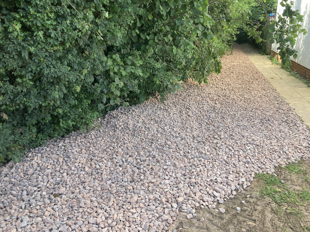
(Editor’s note: with the exception of fitting a trash screen!)
3. Highways works completion
- Confirmation of project elements and timescales. Following the site meeting, DWH met with Highways to confirm both the project elements and the project programme. DWH have confirmed that a full programme will be provided to the TRRA by 23rd July, and that the duration of works is now expected to take 5-6 weeks. A commencement date has been given for 2nd August.
- Confirmation of location for site compound. DWH confirmed that, as previously, this would be next to the electrical sub-station.
 They also committed to seeding this area, when the works are completed, and to seeding all the other areas that were left unfinished from the previous project in Cadora Way.
 - Removal of ‘Heras’ fencing from its current prominent position in the Public Open Space. DWH confirmed that this would be undertaken within the next week.
**** LIVE UPDATE ****
This has now been completed.
4. Landscaping
- Confirmation of latest landscape layout drawings. DWH confirmed the latest landscape layout drawings (click image to download.)
- Timescales for commencement and completion. DWH confirmed that a new landscaping contractor had been appointed, but that planting had been further delayed due to the COVID self-isolation of the landscaping staff. Tree planting is now scheduled for 3rd August, with shrubs and bushes being planted in the new planting season (October / November 2021).
APPENDIX – Landscaping Management Plan (2017) (LMP)
A further ‘online’ meeting is being arranged between TRRA, DWH and GreenSquare to discuss the failures by the maintenance company to carry out all the maintenance tasks detailed in the current (2017) version of the LMP. TRRA will be represented at the meeting by Simon Oldroyd and Chair, David Barnham.
The full LMP is available to download here.
5. Minutes of the TRRA AGM, 27th October 2022
by, Donna Albon
1. Chair’s Statement by David Barnham
- Welcome all to the 2022 TRRA AGM.
- Reason for delay in AGM – availability of room, awaiting important updates, availability of Committee members (working full time).
- Thank you to the current committee – Amazing job.
- What have we achieved since the last AGM.
- Continued to work with organisations to deliver the estate to plan.
- Removal of Heras fencing
- Planting of trees
- Completion of safety survey
- Installation of fencing around the central green area
- Installation of bike chicane
- Improvements to Thurstans Rise flooding issues
- Working with land maintenance team to improve the green space
- Working with GreenSquareAccord in support of the eventual takeover of ground maintenance
- Working with housing organisations in support of the site
- TRRA Website
- TRRA Managed Events
- 2021 Summer fete & Halloween
- 2022 Easter, Queens Jubilee with Halloween just round the corner
- Hard work that goes into organising each of these events, noting all time is given voluntarily
- Working with the town council to deliver new updates and support to the estate.
- Liaison with FOD council with regard to ‘Section 106’ monies
- Phone Box Project
- Salt Bins
- Liaison with Gloucestershire council with regard to road adoption and other road issues (dropped kerb)
- Environmental Planning, flooding etc.
- Working with / supporting individuals to resolve issues where appropriate.
- What are we currently working on:
- Farmers Hedge – seeing if we can provide support to the residents who live on that side and get an agreement put in place with mediation
- Grit Bins – some have appeared, more to follow
- Dog Fouling – requested dog foul bins for the estate and notified dog warden
- Footpath – between Blakes Way and the Oakfields estate needs dropped kerb – potentially being worked on imminently as it has been marked up
- Anti-Social Behaviour on estate – large amount and lack of confidence in the way the police are handling it. TRRA will contact the police and/or Crime Commissioner with whom we have access, to arrange a community meeting solely for the purpose of tackling the anti-social behaviour on the estate and to ensure residents feel safe in their own homes AND supported by the local police
- Red Phone Box / Red Box project – ongoing
- ‘Section 106’ Monies – Council are investigating this and its whereabouts
- Road adoption – ongoing. Not likely to be within 12 months as works still ongoing
- Flooding issues continued – TRRA will chase up the previous meeting outcomes with the flood assessor
- Litter – thanks to those on the estate who regularly conduct litter pick-ups. It was suggested that we could hold a litter picking day as a group to encourage children in the estate to join in
- What is next for TRRA
- Proposing a zero membership fee policy which sees all home owners and renters as automatic membership… to be voted on later in a future date TBD meeting.
- New way of working for TRRA concentrating on community development and support. This will concentrate on 4 main annual events:
- Easter Egg hunt
- Summer Fete
- Halloween
- Christmas Family Evening
- Outdoor Cinema event
- TRRA Website – we would like to continue to utilise this but recognise that we need to use it more!
- How to be funded?
- Zero Fees has been proposed based on the financial statement from the Treasurer which suggests TRRA can fund itself using:
- Summer Fete Profits
- Summer fete sponsorship (Council, organisations… ETC)
- AOB raised by attendees
- Parking, both unsafe and commercial vehicles which are prohibited under the covenants. Once road is adopted there will be more power to try to enforce this. Memo to be sent out to households to encourage safer and correct parking.
- Lifebelt by the ‘pond area’ identified as unsafe via official risk assessment. This is due to it being un-maintained and therefore could be unsafe to use. It might be that the management company take over the management of this in the future.
- Antisocial behaviour raised again by attendees so TRRA will action this as a priority.
- Election of the committee voted by attendees
- Chairman: David Barnham
- Treasurer: Philip King
- Secretary: Donna Albon
- Treasurers report
- Current bank account with HSBC – fees for the account are rising.
- Therefore in the process of switching to a Virgin Money online account.
- Website will be updated once completed.
- Currently we have funds in the bank from grants and community events.
- The Financial Statement for 2021-2022 is available to download here.
- Thanks
- To all for supporting
- To CTC for supporting us and allowing us to use this facility.
- A huge thank you to the committee members who deliver this excellent work on your behalf.
- Continued to work with organisations to deliver the estate to plan.